


NEW YORK CITY – The remnants of Tropical Storm Chantal could bring heavy rain, strong winds and potential flash flooding to parts of the New York City area and New Jersey.
JUMP TO: IMPACTS l TIMELINE l RADAR
“That tropical moisture is feeding in this direction, running up against a cold front, and that’s why we have the showers and storms in the forecast for you, especially in the afternoon,” FOX 5 NY’s Mike Woods said.
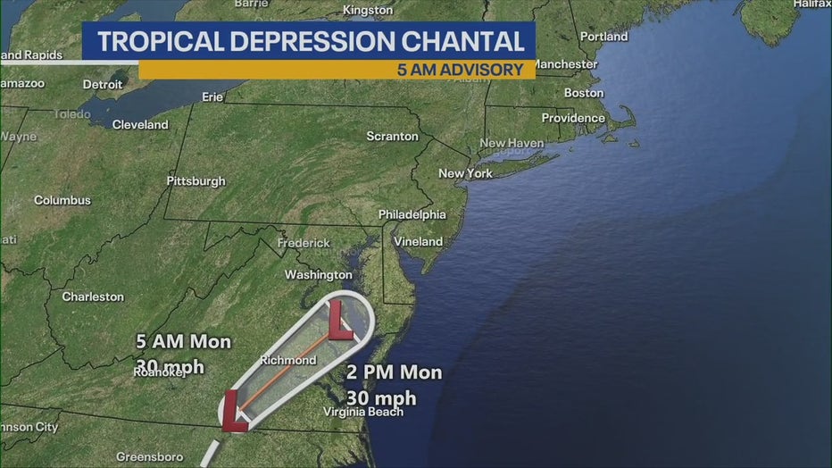
Here’s the latest on Tropical Depression Chantal, including impacts on the New York City area, a timeline of when to expect rain and a look at the local radar.
What we know:
The National Weather Service (NWS) has New York City under a marginal risk of flash flooding, while parts of New Jersey are under a slight risk. The NWS highlights that area as the “greatest threat for flash flooding.”
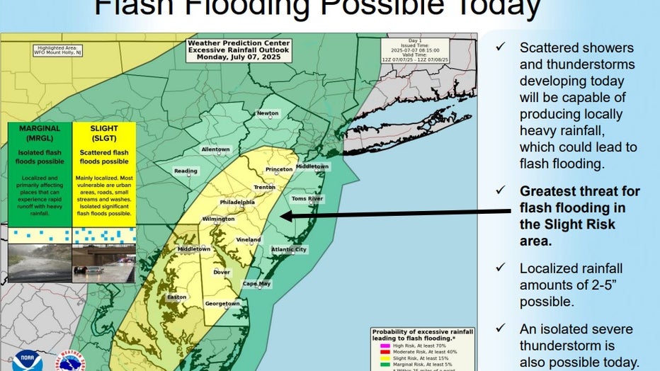
Photo credit: The National Weather Service.
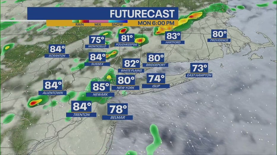
Meanwhile, scattered showers on Monday will be capable of producing locally heavy rainfall, which could lead to flash flooding. Localized rainfall amounts of 2-5″ are possible, the agency said.
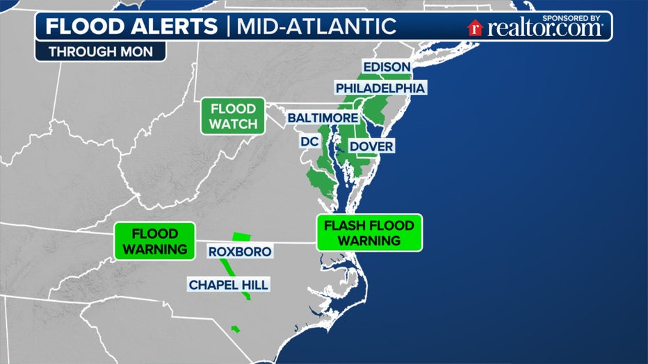
This graphic shows the Flood Alerts Monday for the Southeast and mid-Atlantic. (FOX Weather)
“An isolated severe thunderstorm cannot be ruled out, however the main threat with today’s activity will be the potential for flash flooding,” the NWS said.
Timeline:
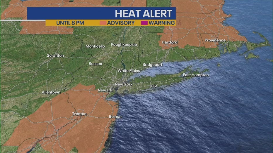
Heat advisories are in place for parts of New Jersey from Monday 10 a.m. to Tuesday 8 p.m.
Heat advisory
- Monday night: Showers likely and possibly a thunderstorm before 8 p.m., then a slight chance of showers and thunderstorms between 8 p.m. and 2 a.m. Some of the storms could produce heavy rainfall. Mostly cloudy, with a steady temperature around 79. The chance of precipitation is 60%.
- Tuesday: A 50% chance of showers and thunderstorms after 2 p.m. Some of the storms could produce heavy rainfall. Mostly sunny, with a high near 87.
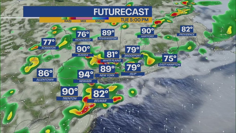
- Tuesday night: A 50% chance of showers and thunderstorms. Some of the storms could produce heavy rainfall. Mostly cloudy, with a low around 75.
- Wednesday: A chance of showers, with thunderstorms also possible after 2 p.m. Partly sunny, with a high near 82. The chance of precipitation is 40%.
- Wednesday night: A chance of showers and thunderstorms. Mostly cloudy, with a low around 73. The chance of precipitation is 40%.
- Thursday: A chance of showers, then showers likely and possibly a thunderstorm after 2 p.m. Cloudy, with a high near 77. The chance of precipitation is 60%.
- Thursday night: Showers likely and possibly a thunderstorm before 8 p.m., then a chance of showers and thunderstorms between 8 p.m. and 2 a.m., then a chance of showers after 2 a.m. Cloudy, with a low around 72. The chance of precipitation is 60%.
- Friday: A chance of showers, with thunderstorms also possible after 2 p.m. Mostly cloudy, with a high near 78. The chance of precipitation is 30%.
- Friday night: A chance of thunderstorms before 8 p.m. Mostly cloudy, with a low around 72. The chance of precipitation is 30%.
‘Much more tropical feel’
What they’re saying:
“We have a much more tropical feel back in the tri-state region,” Woods said. “Expect lots of clouds today with scattered showers and storms mostly in the afternoon and the evening as remnants from Chantal head this way.”
North Carolina weather: Latest
Big picture view:
Over the weekend, hundreds of roads were flooded in central North Carolina after rounds of heavy rain washed out roads, sent rivers into major flood stage and prompted water rescues.

This image provided by the National Oceanic and Atmospheric Administration (NOAA) shows Tropical Storm Chantal as it moves from South Carolina into central North Carolina on Sunday, July 6, 2025. (NOAA via AP)
A state of emergency was declared in Orange County, North Carolina, where the emergency services department reported that water rescues and evacuations were underway late Sunday night.
Chantal made landfall as a Tropical Storm near Litchfield Beach, South Carolina, around 4 a.m. Sunday and carved a path through central North Carolina, where some locations received as much as nine inches of rain within 24 hours.
What’s next:
“Scattered showers and thunderstorms are expected to develop again both Tuesday and Wednesday afternoon and evening,” the NWS said.
FOX Weather LIVE updates
Click HERE for more information.
